
While attention has been focused on Hurricane Dorian as it ravages the Bahamas and menaces the Southeast coast of the U.S., another tropical system is threatening Mexico this week as hurricane season nears its peak.
The National Hurricane Center said Tuesday after that a disturbance in the Gulf of Mexico has become Tropical Storm Fernand, the sixth named storm of the season.
The system currently has sustained winds of 40 mph and is located about 160 east of La Pesca, Mexico and moving west at 7 mph.
A tropical storm warning has been issued in Mexico from Barra del Tordo to the Mouth of the Rio Grande River on the U.S. border with Texas. An NOAA Hurricane Hunter aircraft is scheduled to investigate the storm Tuesday afternoon to provide more information on the intensity.
“A motion toward the west-northwest is forecast tonight and Wednesday,” the NHC said. “This motion could bring the center of Fernand near or over the coast of northeastern Mexico late Wednesday.”
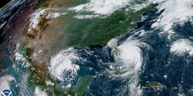
Satellite photos from National Oceanic and Atmospheric Administration show the area of disturbed weather in the Gulf of Mexico as Dorian spins off Florida.
“Interests elsewhere along the northeastern coast of Mexico and the lower Texas coast should monitor the progress of this system,” the NHC said.
The development of this latest tropical system comes as Hurricane Dorian lurks off Florida, and the entire tropical Atlantic basin has become “quite active” in recent days.
“There are currently 3 disturbances being monitored for potential development, with another tropical wave expected to move off the African coast later this week,” the National Weather Service said on Twitter Monday.
While the focus has understandably been on Hurricane Dorian, the entire tropical Atlantic basin has become quite active. There are currently 3 disturbances being monitored for potential development, with another tropical wave expected to move off the African coast later this week pic.twitter.com/qwP3qz3YYj
— NWS Eastern Region (@NWSEastern) September 2, 2019
Colorado State University hurricane scientist Phil Klotzbach noted on Twitter the “whopping” four areas of potential development over the Atlantic over the next 5 days.
“The climatological peak of Atlantic hurricane season is around September 10,” Klotzbach said.
In addition to #HurricaneDorian, the National #Hurricane Center is now monitoring a whopping 4 areas for potential development in the Atlantic over the next five days. The climatological peak of Atlantic hurricane season is around September 10. pic.twitter.com/CC79kXQmOT
— Philip Klotzbach (@philklotzbach) September 2, 2019
On the other side of Mexico, a major hurricane is well off-shore in the Pacific. The NHC said Hurricane Juliette is packing 125 mph winds as it moves northwest at 8mph about 455 southwest off the southern tip of Baja California. Hurricane Juliette, while well off the coast, is expected to send elevated surf with strong rip currents to San Diego County in California on Wednesday and Thursday, the San Diego Union-Tribune reported.
A satellite photo from NOAA shows the scale of tropical activity in the Atlantic and Pacific oceans at the moment.

In the Gulf of Mexico, officials warn that tropical storm conditions will affect the northeast coast of Mexico during the day on Wednesday.
“Squalls with gusts to tropical-storm-force are likely north of the warning area along portions of the northeastern coast of Mexico and the lower Texas coast,” the NHC said.
NEW: Satellite wind data indicate that Tropical Storm #Fernand has formed in the SW Gulf of Mexico. The Tropical Storm Warning has been expanded for the coast of northeast Mexico and is now in effect from Barra del Tordo to the Mouth of the Rio Grande. https://t.co/tW4KeGdBFb pic.twitter.com/6KYNRWciCz
— National Hurricane Center (@NHC_Atlantic) September 3, 2019
The system is also expected to bring 6 to 12 inches of rain across northeast Mexico, and two to four inches of rain for south Texas and the lower Texas coast.
NOAA forecasters have called for 10-17 named storms in the Atlantic, of which five to nine could strengthen into hurricanes. Of those storms, there will be two to four major hurricanes, which are classified as Category 3, 4, and 5 with winds of 111 mph or higher.
The 2019 Atlantic Hurricane Season runs from June 1 to Nov. 30, and this year includes the names: Andrea, Barry, Chantal, Dorian, Erin, Fernand, Gabrielle, Humberto, Imelda, Jerry, Karen, Lorenzo, Melissa, Nestor, Olga, Pablo, Rebekah, Sebastien, Tanya, Van and Wendy.


