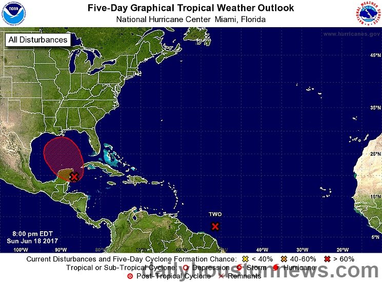
The National Hurricane Center has been monitoring a couple of areas of disturbed weather for several days, one of which could have implications for the Texas coastline. Before digging into the one closer to us, let’s look at what has just become Tropical Depression two of the 2017 season.
It’s way out in the southern Atlantic heading toward the Windward Islands. While forecasts do call for it to reach tropical storm strength over the next few days, when it reaches the Caribbean, high wind shear and generally unfavorable conditions are expected to dissipate the storm rather quickly. In short, this depression poses no real threat to us.
Now, the second disturbance is currently just off the eastern coast of the Yucatan Peninsula moving north northwest at a rather slow pace. The National Hurricane Center is giving it an 80 percent chance of developing into at least a tropical depression within five days.
Most of the forecast models are in agreement that the storm will likely strengthen once it reaches the warm waters of the Gulf of Mexico, though none of them predict it will reach hurricane strength. Nevertheless, it bears watching because we’re in hurricane season and anything is possible. And even if it only reaches tropical storm strength, anyone who remembers 2001’s Allison knows that it doesn’t have to be a hurricane to wreak havoc on an area.
Where it is heading is another story. This is a huge area of low pressure and, as such, it is difficult to define. Finding a center of low pressure is not yet possible and until a center forms, forecast models will have a difficult time assessing all the variables necessary to make accurate predictions. Right now, the two main models diverge rather widely, with one taking the storm west with a landfall in northern Mexico or southern Texas, while the other has it moving more to the north and hitting the central Gulf Coast. At this point, either is a reasonable assumption.
If you’ll notice, however, Houston seems to be smack in the middle of that “cone of uncertainty,” so it is worth watching for development over the next few days. Whatever development does occur, it will be rather slow and probably wouldn’t impact us until after Wednesday.
If the storm stays east of us, it is likely we will see little to no impact from the storm. For the uninitiated, the wet side of storms is east of the storm’s center, while the west side tends to remain on the drier side. However, if the storm hits anywhere from, say, Corpus Christi north to the Texas-Louisiana coastline, we would expect to receive quite a bit of rainfall as a result.
For now, we can’t fully predict what will happen, so the best advice is to keep an eye on things and be prepared.


